New from the Medieval Research Blog: "The Tragic Geology of the Byzantine City of Tralleis 'Andronikopolis'"
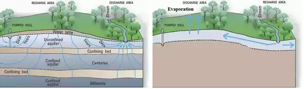
The curious story of the re-founding of the city of Tralleis into Andronikopolis by the soon-to-be-emperor Andronikos II Palaiologos and its quick demise at the hands of the Turkish founder of the Meneteşe Beylik contains a bit of Byzantine speculation on a geological process: the movement of groundwater. The citizens of the rebuilt city, once besieged, found themselves unable to draw water from wells. The source of this story, George Pachymeres, offers a naturalistic explanation for why the city could be so easily driven to thirst (Chronicle I.191, starting with “The cause, I think, was the porous nature of the plain…”).
To summarize his explanation, Pachymeres images an entire underground water cycle, whose movement was a geological game of “keep away” from the depths, where it was needed to pool before being drawn by the thirsty people of Tralleis (see Fig. 1, Right). It is an elegant and sophisticated natural explanation for a writer who did not benefit from the advances in geological scientific thinking since the thirteenth century. The explanation has interesting interactions with modern geological explanations for groundwater movement through aquifers. An aquifer is a body of saturated rock or sediment through which water can move easily. Moreover, Pachymeres is really describing an unconfined shallow alluvial aquifer. Unconfined aquifers—named so because no layer of impermeable material stood between the aquifer and the surface—were dependent upon the level of water in the water table (Fig. 1, Left). Such aquifers are common in river environments in the alluvial soil deposited by the river itself. The Byzantines themselves called alluvial soil “yellow” or “riverine” in the Geoponika (a Byzantine treatise on agriculture written entirely from older texts) and in land survey manuals used by bureaucrats to calculate tax and lease rates.
This is an excerpt from "The Tragic Geology of the Byzantine City of Tralleis 'Andronikopolis'" by Tyler Wolford, Ph.D., 2024–25 Medieval Institute Byzantine Postdoctoral Fellow. Read more.